Research a coastal community, profiling physical, cultural, and other characteristics.
1.
Research a coastal community. Gather information about the village, town, or city: Locate it on a map, find out about its physical geography, cultural climate, and typical architecture.
2.
Make two lists with Crayola® Markers. First, imagine what you might see (natural and manufactured things) in the water if you looked out from the land. Then list what you might see on the land when looking from the water. What building styles and visible clues to cultural characteristics are evident?
3.
With Crayola® Oil Pastels, make a detailed drawing of the coastal community you selected. Begin by dividing your drawing paper for land and water. Blend pastels by rubbing with a fingertip or paper towel. Add details by using pastel over pastel.
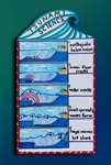
Tsunamis, or gigantic waves, are one of the most destructive natural disasters. Discover how they’re formed, deep under
Caring communities include space for nature! Create a convincing ad for a home for a native plant or animal.
Have you read Maya Angelou’s Life Doesn’t Frighten Me? What worries you? Turn your concerns over to a Worry Warrior and
Where do your favorite things originate? Discover how world economies depend on each other to create materials, products
Make a weather mood collage using colorful papers you create yourself using cool new mixed media techniques and your fav
Imagine you've found the lost underwater city-nation of Atlantis as you use Crayola® Tempera Paint, Markers, and Colored
Find out how sheep fleece is turned into wool yarn by hand, then show what you know in a 3-D shadowbox.
Snow is so cool! But how is snow formed in the atmosphere? What effects does snow have on our lives? Create this amazing