Jump into Japan's geography with a 3-D topographic map! Students will proudly display these models of Japan's mountainous islands and bodies of water.
1.
Research the islands of Japan. Find out where they are located in the world. Identify the largest four islands' shapes, names, and characteristics.
2.
Use Crayola® Model Magic to create 3-dimensional scale models of Japan's islands. Show mountains, rivers, and lakes. Dry.
3.
Paint the islands and their geographic features with Crayola Washable Paint and Paint Brushes. Dry.
4.
Paint ocean waters surrounding the Japanese islands with Crayola Watercolors on a large sheet of paper. You may want to dampen your paper first to try a wet-on-wet technique. Dry.
5.
Place your four islands on the water in their correct locations. Label the Sea of Japan, Pacific Ocean, and island names if you wish.
Explore and respond to the work of Marcel Duchamp, creating a collage of a reworked face.
St. George’s Day (or any day) is the perfect time to celebrate brave deeds. Create colorful bravery badges for yourself
Who is your hero or heroine? Create a unique, handmade book that tells the story of bravery, such as Kate Shelley’s rema
Build a replica of a house using the local materials and construction methods of Brazil! Discover the people and resourc
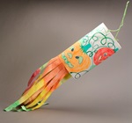
Catch indoor breezes with a colorful windsock! Whether you’re learning about Japan, weather, or aviation, Crayola® Twist
Discover the famous black pottery of New Mexico! These drawings capture both the matte and shiny surfaces of these uniqu
Ready to be a fearless explorer? Create a spaceship flying among strange new planets, where stars have no limit!
Blackbirds are popping from this pie! Find out the origins and meaning of your favorite childhood rhymes.