Can you identify a state or country from its outline? Are you able to fit the states or provinces of your country together? Try it outdoors—on a giant, colorful map!
1.
What is your state or country’s shape? Does it have a distinctive border or an unusual shoreline? Do you know where key areas are located? Can you identify where you live?
2.
Ask your teacher to help you find a safe, large area outside to draw your map. Start by drawing your state or other area that you are studying with Crayola Giant Sidewalk Chalk. Fill the space with color.
3.
Ask a classmate to draw and color a bordering geographic area with a different color.
4.
Continue mapping and filling the regions with color. See how much of the country or world you can draw from memory. Look at an atlas to check on details.
5.
Can your classmates identify the geographic area you created? Add visual clues or words if necessary until they figure out what you drew.
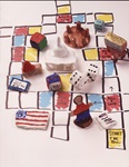
Cast your vote, prepare a budget, or propose a new law with this unique game! Use Model Magic® to create a board game to
Can you identify a state or country from its outline? Are you able to fit the states or provinces of your country togeth
What symbols or logos would you use to represent the three branches of the U.S. government? Mark important passages in y
Explore and respond to the work of Marcel Duchamp, creating a collage of a reworked face.
How can your class become a community of learners? These self-portrait paper dolls encourage everyone to become better f
Library windows are just the place to share reviews of favorite books. Use Crayola® Washable Window Markers or Crayola W
Stick up for sharp-toothed creatures who get a bad rap! They are just trying to survive like all other animals.
What’s at the center of a galaxy? A black hole! Look WAY beyond a black hole by creating a vivid galaxy and observation